")
")
References
For further information please use our contact form.
Brenk Systemplanung GmbH
Bundesministerium für Wirtschaft und Energie
CBM GmbH
Energy & Mineral Resources Group - RWTH Aachen
Institut für Markscheidewesen - RWTH Aachen
Johannes Nickel GmbH & Co. KG

Ministerium für Umwelt, Landwirtschaft, Natur- und Verbraucherschutz des Landes Nordrhein-Westfalen
Mitteldeutsche Hartstein-Industrie AG
Nivelsteiner Sandwerke und Sandsteinbrüche GmbH
Quarzwerke GmbH
Remondis
SST Prof. Dr.-Ing Stoll & Partner Ingenieurgesellschaft mbH
Technologie der Energierohstoffe
Cerence Inc.
Deutsche Bahn AG
Hartmann Gruppe
indurad GmbH
Intrabit GmbH
KFW
K+S Aktiengesellschaft
Lhoist S.A.
Nuance Communications, Inc
Open Grid Europe GmbH

Tierheim & Tierschutzverein für die StädteRegion Aachen e.V.
Technische Hochschule Georg Agricola
Berufsgenossenschaft Rohstoffe und chemische Industrie
GEOVIA SURPAC
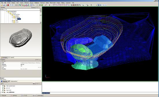
Nowadays, the deployment of modern planning software is one of the basic requirements for adequate and customer oriented execution of mine planning. FUMINCO uses GEOVIA SURPAC for planning tasks. It is, however, also possible to import and process data from other software solutions, such as DataMine Studio. GEOVIA SURPAC is a comprehensive CAD system that allows for the planning and management of opencast and underground mining projects in every phase of the process.
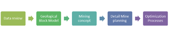
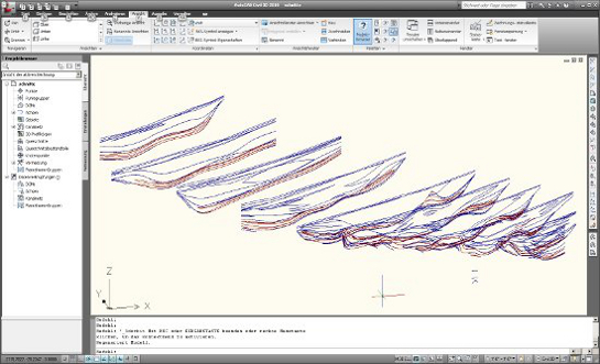
In the context of the creation of a geological model, the first step is to acquire and process a vast amount of geological data. Additionally, a check for plausibility is conducted. Detailed information about the deposit are usually gathered by drilling exploratory boreholes. This information is imported into GEOVIA SURPAC via database functions. The software intern drill hole database can process information about the course of the drilling and about the geology of the drilled hole. The next step in modelling a deposit is the creation of 3-D geological profiles.
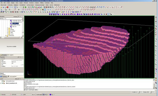
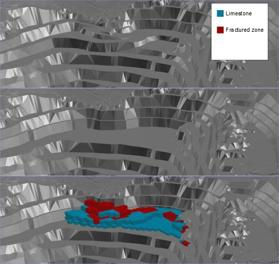
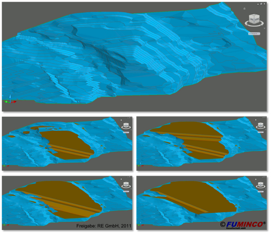
In order to be able to display a detailed map of the deposit, a so called block model is created based on the drill hole database and the 3-D profile data. The big advantage of a block model is that the deposit body is fragmented into geometrical entities, which allows for cutting or delimiting of the deposit body for different planning stages and thus for exact calculations of volumes.
The last step in the development of a geological block model is the implementation of the geological, hydrological, chemical and physical data from the drill hole database into the corresponding blocks by applicating of geostatistical methods such as "inverse distance" or "nearest neighbour". The implementation happens by using user defined block attributes, of which 256 can be saved per block. The work focus lies here on the mining material. In a coal deposit, for example, the following values are of importance for mine and power plant planning:
- Contained water
- Contained ash
- Contained Sulphur
- Calorific value
- Density
The geologial work is concluded by the creation of a comprehensive documentation and the presentation of the deposit parameters on the basis of so called theme maps and geological profiles. These theme maps are used for controlling and are the basis for the next step in the planning process. The following maps are needed:
- Overburden : Coal - ratio
- Quality maps (i.e. contained Sulphur) for each coal seam
- thickness maps (single and overall thickness)
The 3-D block model is the basis of all further planning processes. The mine planning itself starts with the gathering of all available and relevant parameters, such as the clients planned annual production or the required slopes. In the context of the mine planning the next step is the development of the "final pit", which is the basis for a rough planning of the mining process and the required dumps. This first step of planning also includes a preliminary planning of transport routes. This povides a dependable basis for several different planning scenarios, which will be modelled in the further course of the project. Also theme maps can be created for every sector individually.
Based on the individual sectors multiple exposure scenarios will be developed in cooperation with the client. Several factors need to be taken into account when selecting the best scenario: The exposure location should be the place of coal in the least possible depth in order to be able to assure a good overburden / coal - ratio. The maximum final depth is another important factor. GEOVIA SURPAC allows the creation of multiple scenarios which can be evaluated based on mining and economic methods, which allows a custom made and optimal solution that can be presented to the client. The individual scenarios usually differ by different required annual productions or final depths of the pit.
When the best scenario was selected, a per-segment planning of mining and dump with proceeding stages from exposure to final pit is conducted. The masses of coal and overburden are calculated accordingly. The layout of the coal seams happens depending on the used equipment, the selection of which is conducted in cooperation with the client and based on the required production amounts and mining directions.
An optimisation of mining in open pits is accomplished by calculating centres of mass. The planning of transport routes and the locations of required infrastructure, such as location of crushers, is conducted accorrding to these centres of mass.
An ongoing controlling of each step in the planning process is primarily accomplished by the utilisation of a second planning software. The results of of the calculation of each mining stages volume based on the block model is verified by a second software: AutoCAD Civil 3D. This CAD software is not able to calculate the volume of individual seams and layers but can calculate the entire volume of a mining stage, which should be identical to the volume calculated with GEOVIA SURPAC. The entire planning of the dumps is conducted with AutoCAD Civil 3D.
The mine planning process is concluded by a comprehensive documentation of the results and the creation of maps and blueprints. For further information about the application of GEOVIA SURPAC please see the GEOVIA homepage.
In cooperation with our clients we also develop tailor fitted software solutions in the context of projects. Based on the presentation software MS-PowerPoint and Visual Basic for Applications (VBA) we developed an interactive Quiz which can be extended and adopted by the client.
For this Quiz a random number generator selects four questions out of an arbitrarily sized pool of questions. Each question presents four answers to the user, only one of which is correct. The user has to choose the right answer by clicking on it. If the answer is wrong, an explainatory text can be displayed which can tell the user why his answer was incorrect. This allows direct feedback for the user and can help him understand better. The question must then be answered again. If the answer is correct, the next randomly picked question is displayed.
AutoCAD Civil 3D
AutoCAD Civil 3D is used by FUMINCO as planning software for opencast mining projects. Main fields of deployments are dump plnanning and final presentation of the project (maps and blueprints). The software allows for the transfer of coordinate system options and transformations, the processing of survey points and the automated creation of survey lines and digital 3-D landscape models. This results in a consistant planning environment which can utilise points, lines and surfaces for the entire planning process.
Dump planning is supported primarily by tools for 3-D profile bodys and projection intersections. Slope lines, for example, can be projected on a certain height/depth which enables the planner to exactly lay out the slope gradients and seam widths.
In the course of opencast mining projects AutoCAD Civil 3-D is also used for many support tasks. On the one hand, it is used to perform controlling on mining stages that have been created with GEOVIA SURPAC because the calculation of volumes of stages is very precise with AutoCAD Civil 3D. That is why the entire volume of the block model created with GEOVIA SURPAC is recalculated with AutoCAD Civil 3D. The two volumes thould be identical.
On the other hand, transport routes of trucks and conveyor belts amongst other data are primarily digititalised and measured using AutoCAD Civil 3D. It also allows for the simulation of water flow on surfaces in order to create drainage routes.
Another huge advantage of AutoCad Civil 3D is the interactive link between planning and presentation area. Mine planning and documentation (blueprints) are connected in a way that immediately adopts changes in the planning into the blueprints. That is why AutoCAD Civil 3D is FUMINCOs first choice for the creation of maps and blueprints.